OUTLINE
Space Situational Awareness (SSA) means different things to different people, but in its broadest view refers to a knowledge of our near-space environment. This includes both a natural and man-made component. SSA is a term that has become prominent lately due to several collisions of orbiting space objects. This page describes the components of SSA and gives an overview of their significance.
DEFINITIONS
In the broadest sense, Space Situational Awareness may be defined as a knowledge of the energy and particle fluxes in near-Earth space, natural and artificial objects passing through or orbiting within this space, including the past, present and future state of these components. The realm of near-Earth space may be left rather vague at this stage. It is definitely within cis-lunar space, but extends to an Earth-radius of at least 100,000 km to include nearly all man-made objects currently in orbit.
Not everyone agrees with this definition. Some reserve the term only for macroscopic objects in near-Earth space. The Space Foundation states that "Space Situational Awareness refers to the ability to view, understand and predict the physical location of natural and manmade objects in orbit around the Earth, with the objective of avoiding collisions". Not only is this very restrictive, but it is not very useful, as most natural objects do not orbit the Earth, but rather transit through near-Earth space.
The European Space Agency (ESA), however, uses the fuller definition, and specifically lists three segments of knowledge in SSA: "SST - Space surveillance and tracking of objects in Earth orbit (Watching for active and inactive satellites, discarded launch stages and fragmentation debris that orbit the Earth). SWE - Space weather (Monitoring conditions at the Sun and in the solar wind, and in Earth's magnetosphere, ionosphere and thermosphere, that can affect space-borne and ground-based infrastructure or endanger human life or health). NEO - Near-Earth objects (Detecting natural objects that can potentially impact Earth and cause damage)."
The US Strategic Command (STRATCOM), which possesses the largest SST assets on the planet, defines SSA as "the requisite current and predictive knowledge of space events, threats, activities, conditions and space system (space, ground, link) status capabilities, constraints and employment -- to current and future, friendly and hostile-- to enable commanders, decision makers, planners and operators to gain and maintain space superiority across the spectrum of conflict." This includes not only the knowledge of the space segment, but also the ground based capabilities that enable the knowledge, as well as specifying the reason that SSA is important to this organisation.
A good SSA is invariably linked to threats and hazards, but SSA can also provide opportunities to both mitigate or reduce the hazards, and even to benefit from the potential resources present in both man-made and natural debris.
HISTORY
On January 10, 2007, the Chinese launched a KT-2 missile toward an old non-functional Chinese weather satellite (Feng-Yun 1C). The resulting hypervelocity collision demonstrated that China was now the third nation with anti-satellite (ASAT) capability (behind Russia and the USA). It also created the largest cloud of space debris in our space-faring history - debris that will remain in orbit for hundreds of year and debris that routinely threatens the International Space Station several times a year.
The US followed this in 2008 with the destruction of a failed reconnaissance satellite due to re-enter the Earth's atmosphere with a load of highly toxic fuel. Fortunately the debris from this collision was all gone within a few months. The low altitude at which the fragmentation occurred insured that atmospheric drag removed the debris very quickly.
The above two collisions were intentional. However, in February 2009 a collision occurred between an active Iridium communication satellite and a defunct Russian satellite. This was at an altitude that will ensure a long life for the resultant debris cloud. It was really this totally unexpected accidental collision that catapulted the concept of Space Situation Awareness to the fore.
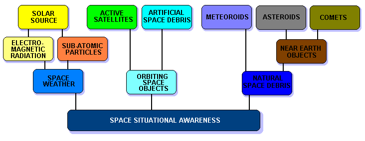
THREE COMPONENTS OF SSA
The figure below indicates the current components of SSA.
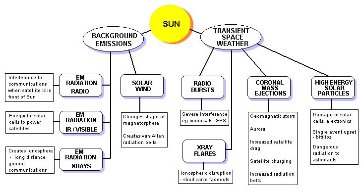
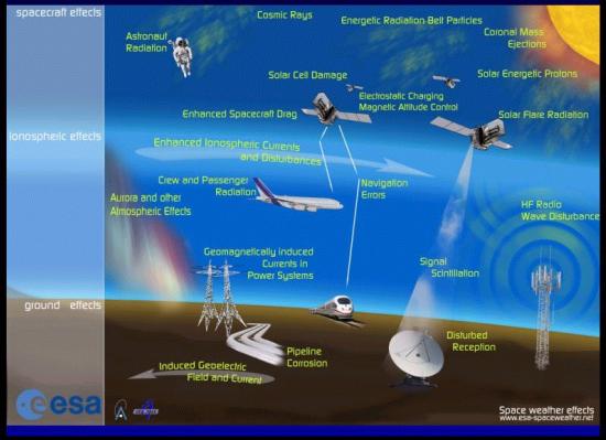
SPACE WEATHER
The source of most of our space weather is the Sun. We can separate this into a background and a transient component. This division and the classification of the sub-components is illustrated below.
NATURAL SPACE DEBRIS
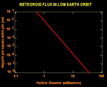
At the beginning of the space age, there was considerable concern about the natural meteoroid flux and its possible impact (literally) on satellites that were placed in Earth orbit. Some of the first scientific sensors on early satellites were meteoroid detectors. Fortunately the natural space debris flux transiting orbit is small enough not to cause serious problems, although a few Space Shuttle windows were replaced due to impacts from small pieces of natural debris (most window replacements however, were due to artificial space debris impacts).
The graph below shows the average meteoroid flux through low Earth orbit. It normally requires a particle of at least one centimetre to cause major spacecraft damage. This flux translates to the expected loss of one satellite every 20 years, given a current active satellite population of around 1000.
Many observatories, including many amateur astronomers are devoted to the detection of near Earth objects (NEO), and routinely provide positional data to the Minor Planet Center. Orbital dynamics and predictions of NEOs are computed and made available via JPL and the University of Pisa NEODYS site.
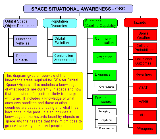
ORBITING SPACE OBJECTS
Overview
Orbiting space objects (OSO) consist of active satellites and space debris. The latter are a mixture of defunct satellites, launch vehicles and pieces of space hardware produced by operational activities, deterioration and fragmentation.
A large part of SSA for OSO consists of the tracking of these objects with the aim of creating a catalog of such objects. The catalog then forms the basis of orbital evolution and conjunction assessment; the latter with the aim of protecting active assets from collision. In the future this will also extend to the minimisation of space debris production through collisions.
SSA also extends to knowledge of the space capability of each space-faring State. Manoeuvre analysis is often necessary in attempts to determine spacecraft functionality. Some states use catalog information to determine overpass times for intelligence spacecraft in order to hide certain ground-based activities from enemy eyes. Human Intelligence (HUMINT) can often provide information that is just as valuable as that provided by technical means, especially in the area of SSA prediction (eg knowledge of a proposed space nuclear explosion that has the capacity to disable a substantial fraction of satellites in low Earth orbit).
The diagram below gives an overview of the areas associated with SSA for OSO.
Orbital Space Debris
Orbital space debris (also referred to as artificial or man-made space debris) is basically any space object or hardware fragment that no longer has a useful function. (Note that some satellites are launched and put in orbital storage until required. These are obviously not pieces of space debris, even though they are currently non-functional).
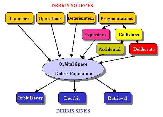
The production of space debris started with the launch of the first artificial satellite, Sputnik-1, in October 1957. Typically, every space launch produces around 100 pieces of debris, from launch vehicles which remain in orbit, to discarded shrouds, to smaller fragments produced by pyrotechnic devices used to separate the satellite from the launch vehicle. The figure below shows this and other debris sources, as well as debris sinks.
In 1978, Donald Kessler published a paper in which he showed that continued production of space debris will eventually lead to a chain reaction where accidental collisions will increase exponentially, creating a debris shell in low-Earth orbit that will render further operations in this orbital space impossible. This condition has even been named the Kessler Syndrome. Because of this, together with the damage that a collision with even a small particle can cause to an active satellite, space debris mitigation is a high priority concern for SSA.
Hypervelocty Collisions
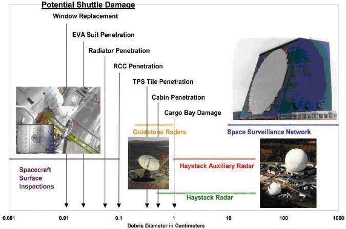
Orbital velocity in low-Earth orbit is around 7 to 8 km/sec. Obviously, collisional relative velocities can vary from near zero up to nearly 16 km/sec. Because of orbital dynamics the average relative velocity between two colliding objects is around 10 km/sec. These velocities are termed hyper-velocities because the kinetic energy carried by a particle at these speeds is in excess of the energy that the same mass of high explosive (eg TNT) would release if detonated. The transitional velocity at which this occurs is around 3 km/sec, when K/m = v2/2 = 4 x 10⁶ J/kg. Hypervelocity collisions thus have more in common with explosive events than they do to low speed collisional events. Even specks of paint can be dangerous. Over 100 windshields of the NASA Space Shuttle had to be replaced due to damage by hypervelocity collisions with paint specks created by degradation of painted surfaces on other satellites.
The figure below is a NASA graphic showing sizes of impactors and the typical effects a hypervelocity collision of such an object would have on the Space Shuttle.
The Orbital Space Debris Population
The figure below is a graph from the NASA Orbital Debris Program Office (ODPO) showing the increase in the orbital space object population since 1957.
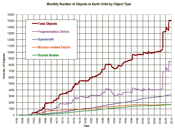
The NASA Orbital Debris Program Office produces a quarterly newsletter ODQN with updates on the tracked orbital space object population, together with news of the latest research findings and meetings related to orbital space debris.
Tracking Orbital Space Objects
The United Nations Office of Outer Space Affairs (UNOOSA) maintains an on-line catalog of objects launched into space. This is compiled from information supplied by member states.
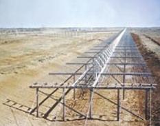
The US has by far the largest network of sensors that track orbital space objects, with some 20 sensors deployed globally. These include radar and optical systems. The prime instrument in this network is a 'space fence', which is an extremely powerful non-tracking radar system located at Lake Kickapoo near Wichita, Texas and other sites across the USA. Below is a US Navy image of the 3-km long transmitter array.
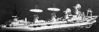
While the US SSN and its SATC are by far the largest source of information on orbital space objects, they are not the only ones who track OSO. Russia maintains its own catalog. Most of the Russian sensors lie in the Asian continent, but this is supplemented by mobile surveillance vessels. One such vessel is shown below (US Navy image).
A group of around 100 dedicated amateur space observers (SEESAT) routinely make observations of the larger space objects in low Earth orbit and produce a catalog of about 100 military satellites that do not appear in the US SATC.
Satellite operators/owners frequently know the location of their assets more accurately than does the US SSN, either through ranging data (GEOsats) or the inclusion of a GPS unit (LEOsats) in their satellite. The US JSpOC has thus set up a Commercial and Foreign Entities (CFE) program to exchange and ingest this data.
The new large array radio telescopes that are coming on line in the next few years may also be a source of space track data, using OSO reflections from existing TV and FM radio transmitters on the ground.
Catalogs, Accuracy and Processing
The SATC currently does not have the accuracy (spatial position) to perform adequate and routine conjunction assessment (CONASS) on the large number of OSO. It also does not contain information on debris down to the critical size of one centimetre. These limitations are basically due to sensor constraints. The US DoD does have plans to upgrade the SSN with equipment that will provide more accurate positional information on all objects down to one centimetre. One example of this is an S-band space fence. The current space-fence operates at the VHF frequency of 217 MHz. An S-band (2500 MHz) version of this will allow detectable returns from the smaller sized objects. Problems with the current US SSN are discussed by Brian Weeden in the Space Review (SR-1), (SR-2) and Defense News. Dr Weeden is a technical advisor for the Secure World Foundation.
Duplication of the newer space fence in the southern hemisphere will also provide a greater number of observations with which to compile a more accurate and complete catalog.
Laser tracking of space objects, currently under investigation by the Australian firm Electro-Optical Systems (EOS) holds great promise to increase the accuracy of data available to generate OSO catalogs.
One of the problems with such an increase in sensor capability is the vastly increased computing power, transfer bandwidth, storage and efficient processing software to deal with this increase in data.
Space situational awareness operators will also require new techniques of data fusion and display to be able to rapidly monitor and interpret changes in the environment of interest, with data incoming from multiple diverse sensor systems spread around the globe and in space.
Some software for SSA is available commercially (AGI) and there is an effort underway to try to develop open source software for this field.
SUMMARY
The number of active satellites is increasing slowly, but the number of pieces of artificial space debris is rapidly increasing and may soon reach a critical population size where accidental collisions will cause a runaway exponential increase in the number of orbital space objects. Monitoring of the near-space environment is becoming more critical to enable conjunction assessment with subsequent collision avoidance in cases of high-value space assets. A new generation of space situational sensors together with an increasing number of states who wish to perform independent SSA analysis is projected to give rise to a large and diverse array of measurements and analysis techniques that will require data fusion and innovative display techniques to give a useful tool for planning and operational purposes. This will need to be combined with space weather data and data on near-Earth objects to provide a truly integrated and meaningful approach to space situational awareness.
ACRONYMS
AGI - Analytic Graphics Inc (US company)
ASAT - Anti-Satellite (Missile used to destroy satellites)
COLA - Collision Avoidance
CONASS - Conjunction Assessment
DoD - Department of Defense (US)
CFE - Commercial and Foreign Entities (US JSpOC program)
EMP - ElectroMagnetic Pulse (produced by a nuclear detonation)
EOS - Electro-Optical Systems (Australian company)
ESA - European Space Agency
GEO - Geosynchronous Earth Orbit (36,000 km altitude)
GEODSS - (US) Ground-based Electro-Optical Deep Space Surveillance system
GPS - Global Positioning Satellite (system)
GW - gigawatts (one billion watts)
HANE - High Altitude Nuclear Explosion
HUMINT - Human Intelligence
IPS - IPS Radio and Space Services (Australian Space Weather Agency)
J - Joule (SI unit of Energy)
JPL - (NASA) Jet Propulsion Laboratory
JSpOC - (US) Joint Space Operations Center
K - Kinetic energy
LEO - Low Earth Orbit (below 2000 km altitude)
MIJI - Meaconing, Intrusion, Jamming and Interference (US military)
NASA - (US) National Aeronautics and Space Administration
NEA - Near Earth Asteroids
NEO - Near Earth Objects (Asteroids and Comets)
ODPO - (NASA) Orbital Debris Program Office
ODQN - Orbital Debris Quarterly Newsletter (published by ODPO)
OSO - Orbital Space Objects (Active satellites and space debris)
SATCAT - (US) STRATCOM Satellite Catalog
SATC - now the preferred term instead of SATCAT
SSA - Space Situational Awareness
SSN - (US) Space Surveillance Network
SST - Space Surveillance and Tracking
STRATCOM - (US) Strategic Command
SWE - Space Weather
SWF - Secure World Foundation
SWPC - (US) Space Weather Prediction Center
TNT - Trinitrotoluene (High energy explosive)
UN - United Nations
UNOOSA - United Nations Office of Outer Space Affairs
US - United States of America (USA)
 Australian Space Academy