INTRODUCTION
Even the smallest nuclear explosives release an energy equivalent to the detonation of several thousand tons of high explosive such as trinitrotoluene (TNT). As such they have a large effect on the surrounding environment (Glasstone & Dolan, 1977).
The energy released in a nuclear explosion is partioned as shown in the diagram below:
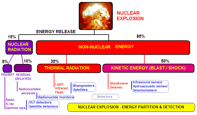
This is strictly for a fission explosion in the lower atmospher (below 30 km altitude). A fusion bomb and a higher altitude explosion will vary in the percentage energies shown.
A nuclear explosion releases electromagnetic energy across the entire spectrum, from radio waves through infrared, visible and ultraviolet light to x-rays and gamma rays. All of these provide a means of detection. The kinetic energy release contains a component of sound waves that propagate through the atmosphere and seismic or sound waves that propagate through the ground. For some time after the explosion (minutes to years), the radioactive materials generated in and by the explosion release radiation that can be easily measured. Very small particles travel as aerosols through the atmosphere to great distances where they may be collected and analysed.
MONITORING
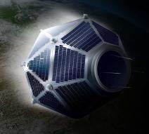
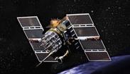
| Every state that possesses nuclear weapons has some form of monitoring program to detect nuclear detonations. The USA probably has the most developed program. Not only ground sensors but also an array of space-based sensors are employed to continuously monitor the globe for nuclear explosions, both underground and in the atmosphere. On achieving access to space, the US was quick to place nuclear detection sensors in space. The first of these were payloads on satellites that were advertised as solar monitoring satellites. The first dedicated satellites were known as Vela (image at right), and these performed well up until 1980, when the role was taken over by the GPS satellite constellation. |
|
When the Comprehensive Test Ban Treaty (CTBT) was introduced in the United Nations, the CTBT Organisation (CTBTO) was set up with one of its tasks to establish an International Monitoring System (IMS) that would be independent of individual nation states (although relying heavily on equipment developed by them). Such an organisation could then make available sensor data without secrecy restrictions that an individual state might impose.
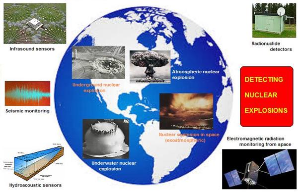
The IMS consists of a large number of ground-based sensors designed to detect underground, underwater and atmospheric nuclear explosion. The emphasis however lies in the detection of underground explosions, which would indicate a nuclear test explosion. Atmospheric explosions have not occurred for some decades, and are more readily detected than below ground explosions. The IMS thrust was toward detection of clandestine underground explosions by states developing nuclear weapons, and for compliance by developed nuclear states.
The IMS consists of seismic sensors to detect undergound and atmospheric explosions, hydroacoustic sensors to detect underwater explosions, infrasound to detect atmospheric explosions and some underground explosions, and radionuclide monitoring stations (plus associated laboratories to anaylse collected radionuclide material).
The only sensors that are not included in the IMS suite of instruments are space-based sensors that can detect the instantaneous electromagnetic emissions produced by atmospheric and exoatmospheric (space) nuclear explosions.
UNDERGROUND NUCLEAR EXPLOSIONS
The most reliable and useful detection of undergound nuclear explosions is through the monitoring of the sound waves that carry away some of the blast energy from the explosion. Many seismometers and seismic arrays exist around the world. The graph belows shows the detection of a North Korean underground nuclear explosion by a seismometer at the Australian Space Academy site at Meckering, Western Australia:
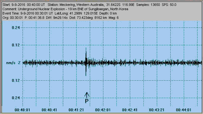
At this distance no information about the seismic event can be obtained. However, several seismometers closer to the detonation can be used to determine the location and approximate yield. A good seismogram can be used to distinguish between an earthquake and a nuclear explosion, and the distinguishing characteristics are discussed by Bolt (1976).
Even though a nuclear explosion may be underground, there is often a leakage of radioactive material (particularly radioactive xenon) into the atmosphere, and this can be detected by aerial sampling or radionuclide monitoring stations quite some distance away.
Underwater nuclear explosions can be detected most readily by the hydroacoustic sensors of the IMS network. These are normally placed at a depth of about 750 metres and connect to a station on the coast by a cable that can be several tens of kilometres in length. These monitoring stations are the most difficult and costly of all the ground stations to set up.
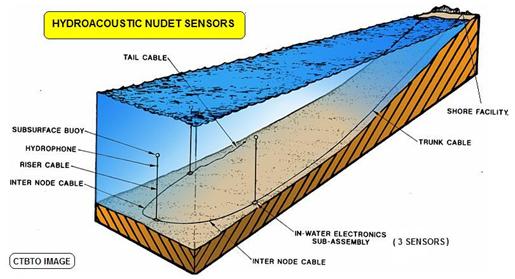
In remote localities the nuclear detection stations are powered by solar photovoltaic panels and send their data via satellite to the central IMS station in Vienna.
ATMOSPHERIC EXPLOSIONS
Nuclear explosions that take place in the lower atmosphere generate a wide range of prompt electromagnetic radiation from radio to gamma rays. They also produce a very low frequency shock wave that propagates as infrasound (with a frequency below the range of human hearing) for vast distances.
| The use of VLF radio waves (3 to 30 kHz) to detect atmospheric explosions received a lot of early study. A device to allow amateurs to detect such explosions was even published by a British magazine, 'The Radio Constructor' in the January 1963 issue (see circuit at right). The utility of VLF detectors however, has proven very limited - too close and the receiver will be destroyed by the very large electrical fields produced (what is known as ElectroMagnetic Pulse or EMP), and more than about 1000 km away propagation effects render the signal almost identical to that from lightning). | 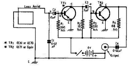 |
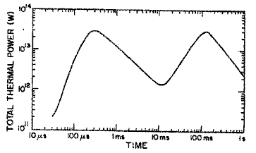
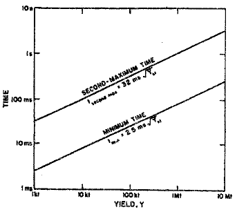
One of the earliest special purpose devices to detect and measure above ground nuclear explosions was called the 'bhangmeter'. This was essentially a photocell connected to some form of oscillograph. The output showed the double hump flash that is so typical and defining of such bursts. It was soon shown that measurement of the time from the start of the flash to the minimum between the two humps was closely related to, and allowed prediction of the explosive energy yield. See the figures below:
 |
 |
THE GPS NDS
| The US GPS satellites now carry a Nuclear Detection System (NDS) as a secondary payload. The NDS consists of a suite of sensors that detect electromagnetic signals over a number of frequency bands. The information is transmitted to the ground at the L3 frequency of 1381.05 MHz, employing spread spectrum modulation similar to that used in the navigation signals. The enviromental data is encrypted and continually broadcast. There is also a capability to cross-link this data to other GPS satellites. |
The diagram below (Image Credit: AJ Bell) shows the various sensors in the GPS NDS:
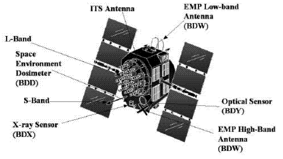
The NDS sensors are:
The BDD is a dosimeter to provide an indication of the ionising particulate and gamma radiation in the environment of the satellite.
Although none of these sensors has imaging capability, they have access to the high precision on-board atomic clocks. These are used to time tag any events detected. Comparison of these times with the times recorded by other GPS satellites allow positional determination of the event source to high accuracy (as with the similar determination of position by the navigation system).
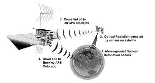
The GPS satellites are situated in a Medium Earth Orbit (MEO) within the van Allen radiation belts. This requires that their systems and electronics be hardened to withstand the high radiation environment. As such, they are uniquely suited to survive in the case of an exoatmospheric nuclear detonation.
If a potential explosive event is recorded on the other side of the world from the USA, GPS satellites have the capability of relaying the information through other satellites in the constellation so that the data can be immediately downloaded to a ground station at Buckley Air Force Base in Denver, Colorado (see diagram below - Image Credit: AJ Bell).
REFERENCES
 Australian Space Academy